
SEATTLE — Puget Sound Extended Forecast
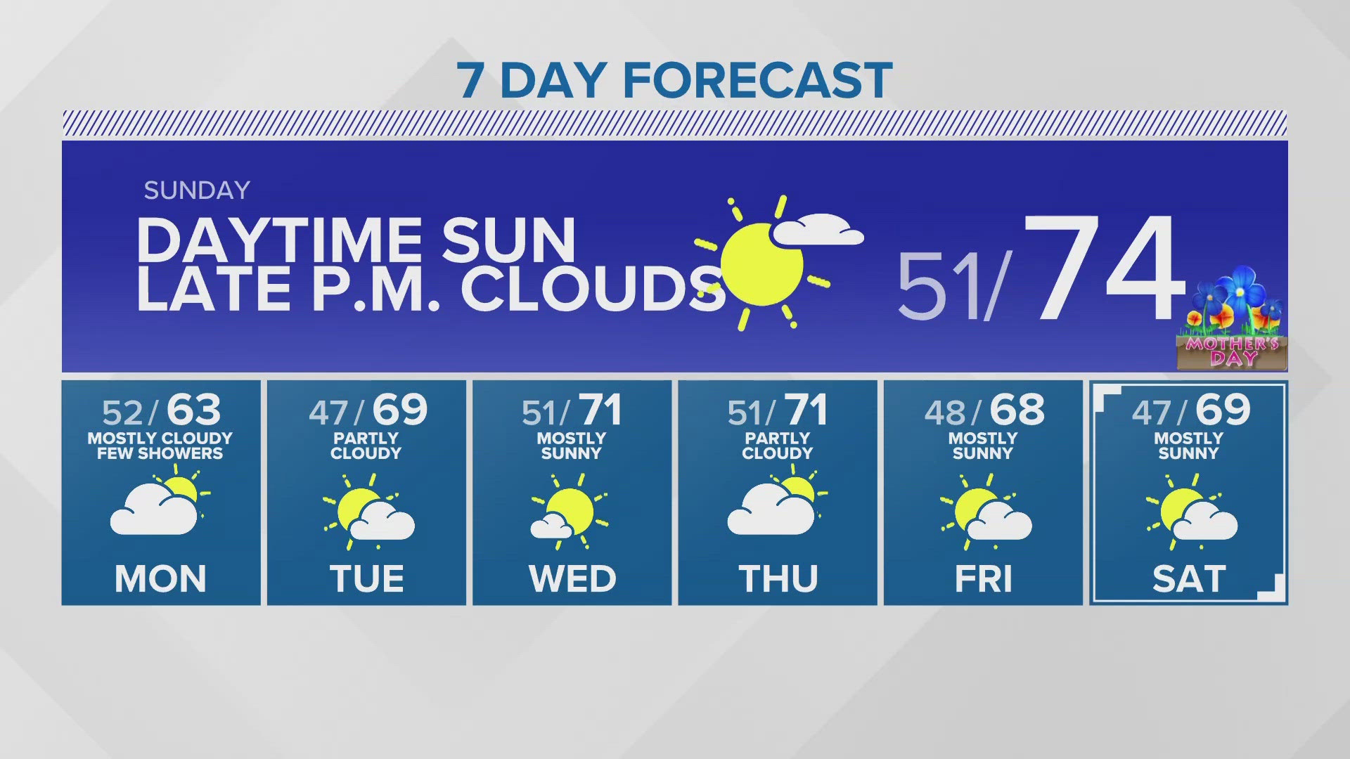
Sunday (Mother's Day): Mostly sunny and mild. Lows around 50 degrees. Highs in the low to mid 70s.
Monday: Mostly cloudy. Chance of a few light showers. Cooler. Lows in the low 50s. Highs in the mid 60s.
Tuesday: Party sunny. Lows in the upper 40s. Highs in the mid to upper 60s.
Wednesday: Partly sunny. Increasing p.m. clouds. Lows in the low 50s. Highs in the upper 60s to lower 70s.
Thursday: Mostly cloudy with increasing light rain. Lows in the low 50s. Highs in the mid to upper 60s.
Friday: Mostly sunny. Lows in the upper 40s. Highs in the upper 60s.
Saturday: Mostly sunny. Lows in the upper 40s. Highs in the upper 60s.
Discussion:
After a summer-like start to the weekend, temperatures are expected to cool as our ridge of high pressure breaks down and a weak disturbance approaches. Saturday, daytime highs peaked in the upper 70s around North Sound and low to mid 80s south of Everett. Olympia hit 88 degrees, which tied the daily record!
Onshore flow is already creeping in along the coast, cooling the Olympic Peninsula Saturday. Cool air will continue to dominate into Sunday, helping drop temperatures back down into the comfortable 70s around the Sound for Mother's Day.
A weak disturbance moves in Sunday, bringing light rain to Vancouver Island Sunday afternoon, but weakening by the time it hits Washington. The Olympic Peninsula will see some clouds to start the day, then that fills into the Sound by the late Sunday evening. This will spread in clouds and a few light showers on Monday, but no major accumulations are expected.
While rain totals look minimal (if anything), the biggest impacts with this next disturbance are the much cooler temperatures that come with it Monday. Highs will drop nearly 20 degrees in a 48 hour span, cooling back to near normal in the low and mid 60s Monday.
We should see partly sunny skies Tuesday and Wednesday, but a chance of a little light rain by midweek. Temperatures are expected to be in the 60s and 70s.
The Northern Lights were on full display Friday night and early Saturday morning in Western Washington due to an extreme (G5) geomagnetic storm event - The last G5 event occurred in October 2003! The strongest geomagnetic activity occurred Friday evening through Saturday morning, but NOAA Space Weather Prediction Center expects at least G4 or G5 conditions tonight and Sunday. Western Washington will have another chance to check out the Aurora tonight. It looks like the best chance will be in the early Sunday morning hours before sunrise (2-4 a.m.).
Best chance of seeing the Aurora is to get away from city lights. The darker the sky, the better your chances of seeing it. And fortunately, we are just past new moon, so there won't be any moonlight to interfere! Also, try to have a clear view of the northern horizon. Take a comfortable chair. Unlike an eclipse, the exact time an Aurora will occur isn't predictable yet.